
We packed up and started out for California, early on July 25th. Made a stop on a corner in Winslow AZ. It is fun place, with lots of people, even in the middle of the week.
Our next stop was Meteor Crater a few miles down I-40 from Winslow. It is all high desert there, with the rim of the crater over 5,000 feet. I felt the altitude while there.
The next day we stopped at Grand Canyon Village on the South Wall. The altitude there is a tad over 7,100 feet, and I did fine there, even walking around for almost two hours. I felt better about my upcoming backpacking trip.
We arrived in Simi Valley that night. I grew up there, and looked forward to seeing it again after more than 22 years away. I hated it, even before we arrived. We arrived during the evening Rush Hour, and just missed being taken out in an accident. A few car lengths ahead, in the lane to our right, a car bumped the one ahead, resulting in that car spinning left and crossing in front of the car in front of us, then completing the spin and heading back the way she came. Smoking tires everywhere. No dents, no injuries, just a lot of pounding hearts and blood pressures that were off the charts.
Simi Valley has more than 126,000 citizens there now, whereas Columbus, Indiana has just under 37,000. The change for us was stark.
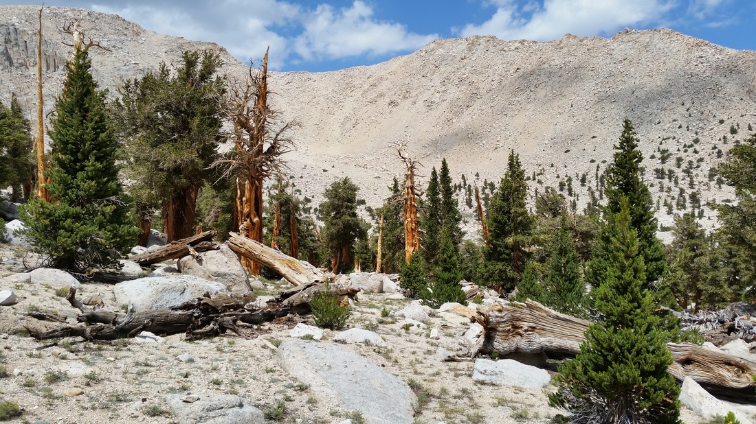
On Friday the 29th I picked up my rental car, and headed for Horseshoe Meadow in the Sierras; altitude 9,990 feet. I wanted to make sure I was acclimatized before the start to Cottonwood Pass, at 11,300 feet.
I arrived to light rain, wind, and thunder off to my northwest. I set up camp, cooked lunch, then did a lot of walking.
First lesson I learned was simple. Don’t leave the windscreen for the stove at home. The weight saved is not all that much, and the increased cost in fuel burn is ridiculous. Wind also makes getting the stove lit a waste of matches.
From about noon to early evening, the campground filled with people. Everyone was friendly and talkative. The standard greeting was, “Hi, where ya headed?” Followed by, “Where ya from?” Then showing off homemade equipment for things you would never think about. One guy had two items, both for his smartphone. He took straws, and two chopsticks and made a folding camera stand for recording the meteor showers while on the trail. The other item was a large rubber band for making one of his trekking poles into a self-stick.
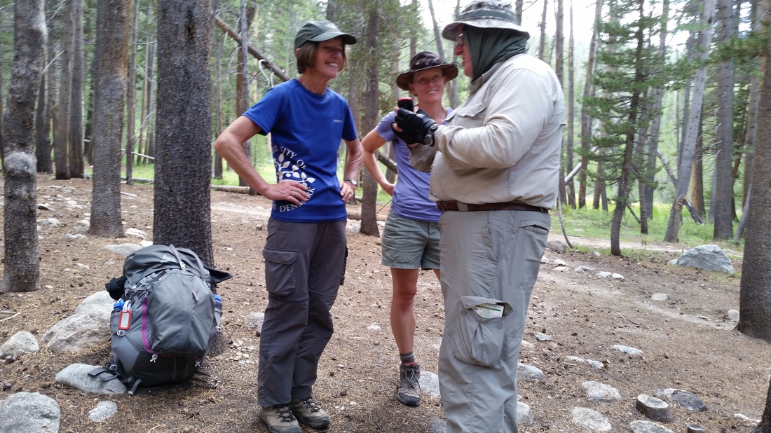
Saturday I got up and drove to the USFS Visitor’s Center, to meet Fred and pick up our permits. The temperature was about 43 degrees. I’m not used to that in August. We were in camp by noon, again to light rain, wind and thunder. A few flashes of lightening could be seen this time.
The campground was almost empty when we got back, however, by evening it was almost full again.
Fred and I took a walk down to the creek that feeds the meadow, the water was low, maybe ten inches deep and 18 inches wide. A Marmot climbed up on a rock and watched us. As we came around the rock on the way back to camp, Mrs. Marmot watched us from the base of the rock.
Our camp is posted as an Active Bear Area. There are bear proof food storage containers placed everywhere, and backpackers are required by regulation to carry bear resistant containers to pack food into for hiking. The bears have long since figured out it is a waste of their time to try and get food from camps, and hikers, so we didn’t see any, nor signs they were around.
The night sky is as nothing one sees at the lower altitudes. Each star is brighter, crisper, sharper, than at sea level. The Milky Way is more defined, more bright, and arcs across the sky, as if it is holding the sky up. You feel as though you could reach out and hold the Big Dipper in your hand and take a drink from the night sky.
There is something almost magical, in drifting off to sleep while listening to the voices in the camp, and crackling the fires dying out.
Fred and I do a lot of walking, getting used to the altitude. I am not as out of breath as I was the first day. I now understand my parents wanting to take a few slow days at altitude when we camped when I was growing up.
The day has arrived, 1 Aug. Our permit is good for the next seven days.
We take our time breaking camp, making sure we leave nothing of importance behind, and also making sure any food left behind, is properly marked and stored in a bear box.
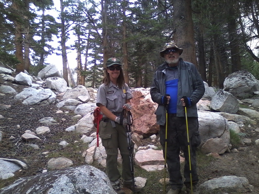
At 0725, Fred takes a picture of me at the trailhead, and we start off. Our first goal is Cottonwood pass, 3.9 miles away. We hoped to be there by noon.
The first part of the trail is flat. Oh, we are climbing to be sure, but for the most part, it is a gradual rise for the first two miles. The map says we gain 310 feet. In the next 1.9 miles we gain 1,050 feet, in a series of switchbacks.
I was not a speed demon, and was huffing and puffing hard when we made the pass at 11:49. We took off our packs and rested for a while, taking pictures, and attempting to see if I could get my phone to pick up a signal. Some claim to have done it, but I couldn’t.
Chicken Springs Lake is about .6 miles downhill from the pass, with a camp another .2 miles up, along the shore line. Here is another lesson. We should have made camp here. Yes, it is still early in the day, but my body has just done something it is not used to, and at altitude. My legs needed to rest, and to adjust. That, and guide books all list this as the end of the first day. Don’t push. Relax and enjoy the view.
We pushed on. Our goal was Rock Creek. This meant a climb out of Chicken Springs. It doesn’t look like much on the map. This leads to another lesson. Distances on a map are misleading. This is the Back Country, not a tourist attraction, where the distances are measured with accuracy, on paved, or well maintained, easy walk trails.
Over the next quarter mile, we climbed from 11,250 feet to 11,500 feet. About halfway up we stopped to rest, and met a solo hiker going the other way. She stopped and talked to us for a few minutes, giving us her “secret route” to Rock Creek. The new route added 1.8 miles to the day’s total mileage goal, however, the one major advantage was that it put us on water earlier, and for most the distance to Rock Creek. The original route is waterless for 8.1 miles. Taking the detour cut that to 4.9 miles.
We continued on, with a little downhill after reaching 11,500. But before reaching the downhill part, Fred scared me a bit. He stopped to take care of nature, then said it was, well, not good. He complained of dizziness. Later when we rested, Fred was behind me, and I heard him hit the ground, pack and all. That I was leading the hike at that point added to my worries.
We pressed on. What goes down, must come back up. We crossed into Sequoia/Kings Canyon Wilderness at 11,250 feet, and headed to our detour at the junction of the Pacific Crest Trail, and the Siberian Pass Trail.
We crossed a dry meadow, meaning no surface water, at about 10,900 feet. Climbing another 100 feet we found the small stream that empties Lower Soldier Lake and becomes Rock Creek lower down. The hike was flat, but it was late, and we were both out of water.
Fred arrived ahead of me, far enough ahead, to have set up camp. I don’t mind stating that I was exhausted at this point, and Fred was suffering leg cramps. It was also dark. The sound of the water at the trail junction was the voice of God to my ears. It is a sound which brings tears. It is a sound that is joyous, and eases the pains of the trail.
This camp, for those that are not keeping track, was our first night on the trail. Ideally, under lessons learned, this should have been our destination for night two.
We didn’t cook a proper meal, instead, we downed a few food bars, and drank water as fast as the filters made it safe to drink.
I slept well, but Fred didn’t. His legs cramped most of the night. He was awake far too much and in obvious pain.
The next morning, the doubts about what we were doing set in. We rested, talked, napped, and talked some more. We also prayed a lot about what to do.
We had a few choices. We could carry on, but exit Whitney Portal, without the proper permit. By this time in the hike we knew that was the only option that would allow us to summit Whitney. Another choice was to turn back the way we came, and yet another was to stay put, and go out Army Pass Trail to New Army Pass the next day. It was a longer way out, but after a climb to 12,250 feet, the way home was all downhill from the pass.
We decided to press on, and exit at the Portal sans permits. It might have worked, had we stayed put and rested for one night. But both of us felt time pressured. Time, we knew we had. But for some reason I don’t yet understand, we felt we had to rush. One more lesson learned. Stop pressing. We had time, we knew, we had time, but instead we thought in terms of miles hiked, and miles left to hike. We didn’t stop and enjoy the walk. We saw others walking at a pace we thought for some reason we must match. We heard people say, we covered 80 miles in eight days. Why? What views and vistas can anyone enjoy covering that much ground?
Sure, we were tired. Sure we needed to reach the trail junction and water soon, but we took in the view at the top of the pass for a few minutes. There should have been more of those times. This was not meant to be a race, and I regret that most of the time we played our hands as though it were. It was as though we told God, “Nice bit of creation, but we need to be at point A by X time and we are too far behind to appreciate your work.”
We made the lower ford of Rock Creek Camp, a distance of about 4.8 miles with daylight to spare, however, the pushing of miles is catching up with both of us, but more so on me. The goal was to be here Monday evening, but its now Tuesday. The summit is still doable, but slipping away.
It is said the first day is painful. The second day is the worst of all, then the body settles down to what is needed to be done. But we have done too much, in too short a time.
At least I am not as winded as on day one, though my energy level is not where it should be by now. The effects of pushing are cumulative, and Thursday morning, I am going to pay for it.
We are up and packed for Guyot Pass. The first part of making the pass starts with the first step off the last rock in fording the river. Our altitude is 9,450 feet; we reach 9,750 in a about a quarter mile. The first set of switchbacks takes you to10,000 feet in about a 10th of a mile.
While on this series of switchbacks I meet a Ranger going in my direction. As with all meetings, we stop and talk. SOP subject, “Where are you heading?”
“We are headed to Whitney.”
“We?” The problem was I was alone, and the word ‘we’ was red flag waved in front of a bull. I couldn’t take the word back, though I felt I should. Why I felt I should, I was not sure.
“Where is Fred?” he asked.
I am tired, working hard to put one foot in front of the other, and under the best of conditions, I am not even close to being clairvoyant. “He’s ahead of me.”
“How far?” he responds.
Now my head hurts. How could I know? Is Fred on the flats up there? Is he struggling at the top of this set of switchbacks? Is he just ahead, sitting on a rock or log waiting for me to catch up?
“I’m not sure.”
“If I see him, what do you want me to tell him?”
Finally, a question that makes sense, and one I can answer. “Tell him to wait for me.” A mundane request, one I knew immediately, was not what he wanted to hear. Even now, I don’t know what he wanted me to say. Or more than likely, I was reading into it, things that were not there.
Fred was waiting for me, sitting on a log, not far from Guyot Creek. Mr. Ranger had caught up with him, and relayed my request.
Fred, said Mr. Ranger was of the opinion we should turn around, that Whitney Trail, at 13,480 was not something he though was within my reach. At this point, every mistake we made has converged upon us, me in particular, to make his opinion a fact we cannot escape. If, if we had three more days… But we didn’t. Time to admit we have bit off more than we could chew.
We rested a while, talking over our mistakes, before heading back. Even though the trail is now downhill, it is a steep downhill, and it takes time to get back. We make one stop at nice flat dry spot between the switchbacks, as a place to eat lunch.
The problem now is I have a mild case of altitude sickness; the food bar doesn’t want to go down. A slug of water, and it goes down and stays. But it scares me a little. I can’t catch a break. Of course it is all my doing.
Lunch finished, we start off again, I take the lead, setting the pace. Mr. Ranger, it seems, had a discussion with Fred about sticking together. I have a feeling in my gut, other things were discussed, I didn’t and I won’t, even now, ask.
We meet Elsa as she passes us on the way down. She is a nice lady, originally from Holland. A few switchbacks later, we come upon her waiting for us. She and her family have miss planned their food allocation, and she wants to know if she and her family can buy whatever extra meals we may have. Of course not, she can have our extra. This is way we do things. At some point she and her family will have extra, and she can pay it forward by helping them. We arrange to meet at the bear box at the ford of Rock Creek. Elsa is shocked that we would not take money. But it is the right thing to do. We depend on each other, and money is not part of the deal.
When Fred and I reach the ford, most of Elsa’s family is waiting on our side of the river. Her eldest daughter is standing at the ford, and I ask her if she is crossing. Her response is “Yes. Give me your pack, you don’t need to worry about your balance making the ford.” God Bless her. I was thankful, and didn’t argue the demand for my pack. I will remember this kindness for the rest of my life.
We sit and visit on the riverbank after fording the river. Elsa makes sure I am downing water as we talk. She and her family summited Whitney a few days before. My hat is full of pins; most are from my time in the Air Force. But one is the pin for summiting Mt Whitney, a motivator for me to make the summit. I remove the pin, and hand it to Elsa, telling her she earned it. She was unsure about taking. I was serious about giving it to her. For a minute, I thought she was going to hug me.
Our visit over, we each head up trail, Elsa and family to Soldier Lakes, and Fred and I to the lower meadow camp site. Elsa helps me one more time, by adjusting my trekking poles. Better balance, and less work using them. I am tired, but feeling better. We make camp in the evening with a lot of daylight to spare. Dinner is good, filling and gives me no problems in going down and staying down. There are others at the campsite, three young ladies, and a young man, all conducting a study of the meadow for the United States Geological Survey.
At some point during the night I get up to answer nature’s call. It is the last clear memory I have for a while. Sunrise finds me confused and out of sorts. I don’t remember waking up or getting out of my tent. I do remember standing next to my tent, looking at it and shivering. I remember asking Fred if it was cold. The morning temps were in the high 30s and low 40s. I was dressed for the cold, so it didn’t make sense to me. Nothing else did either. I have flashes of attempting to eat breakfast. Did I cook it? I don’t know. I think it was scrambled eggs, and I think it stayed down.
Mrs. Ranger came into camp and talked to the researchers for a while. I am sure they told her I was having problems, as she came to our site, and started asking me questions. Fred presented her with our permit, which she seemed to not be interested in at first. Then she was. I recall some concern with the itinerary, too many miles and too few days. I couldn’t follow the discussion, but it seemed Fred was not happy.
Ranger Laura, is married to Mr. Ranger, the Ranger we met yesterday. She is also an EMT, so she asked permission to give me the once over. My vitals were all normal given the altitude, but I was still wonky. She and Fred had a discussion about several things, and though my fog was starting to clear, the details of their talk are not clear. I did get the feeling she was dressing him down. Team work and helping seemed to be a major part of her speech.
A plan was put into place. I was to carry less weight, Ranger Laura even checked my pack to be sure it was lighter. We set off with Ranger Laura leaving us behind. She was going ahead to drop off her pack, so she could come back and take mine from me. We made good time, and my fog over the next hour or so lifted. We had lunch at the bear box at the upper meadow. It went down with ease. We played leap frog with my pack up to the junction of Army Pass Trail and Siberian Pass Trail.
At the junction we met another hiker, and Fred needed to find a tree. I talked with the hiker as a family of three came down the Siberian Pass Trail. A few minutes later, Ranger Laura showed up, saying she wanted to do one last set of vitals on me. “Oh and where is Fred?”
“Finding a tree.”
I crossed the creek, and sat down at our old campsite and waited for Laura, as she talked to the other hikers. I waited a long time. When she came up she said she knew a better, more protected campsite across the trail. She was right, it was perfect, hidden from the trail, but a nice view of the creek. My vitals were great. Fred was still in the trees on the other side of the creek, and Laura was unhappy.
Fred crosses the creek later and Laura calls out so he can find us, then bids us farewell and leaves. Fred is not happy, but says little when I ask. I let it drop, we have more important problems. I have an idea of what took place from what little each said to me, and well, I think both individuals found they didn’t like each other for their own reasons. I won’t pick at that wound. I have respect of both of them, for different reasons.
We set up camp, and Laura popped in, saying the easy way to the trail was not the way we arrived. Then pointed out our exit. She gave me her Sat Phone number. She wanted me to call and leave a message once I was off the mountain and breathing thicker air.
The next day, Friday, we headed up the pass. It was a long grueling hike, and it seemed Chicken Springs Lake was a planet away at times. We took our time and enjoyed the views below us and the vistas in the distances. We wanted to get to Base Camp, but we had lots of time to do it in. We sat and talked with others, laughed, joked, gave and received encouragement. Around noon or so a young man, coming up trial stops me, “Are you Gregg?” The question surprises me. “Ah yeah, I am, why?” Ranger Laura had radioed him asking him to look out for me and make sure I was okay. The Rangers and people you meet on the trail are the best ever.
We arrive at Chicken Springs Lake, I want to go on. Base Camp is 4.5 miles away, and I have a headlamp to finish in the dark. Fred ends the discussion by heading up to the campsite. I am not happy, but know it is not wise to hike out solo when night will catch me on the trail.
We make camp and relax. I take the water filters and head to the lake. The water is warm, as it is not moving. I take off my boots and stand my socks on a rock. The water feels good, and within minutes, tadpoles are nibbling around my toes. My filter is slow, and Fred’s needs to be cleaned. I fill my water bladder to about two liters, and fill two more one liter bottles. Fred takes his turn and does about the same. We have water of meals and the hike out.
I wake up around 3 am. My rain fly is open, so I can see some sky and the streak of a meteor going east. I fall asleep waiting to see more.
We take our time packing up, making sure we leave nothing behind. If we do, unless it is a camera or phone, it stays where we left it.
The climb to Cottonwood Pass is not as bad as I had anticipated. We rest at the pass and take more pictures. We pause at the first step off the Pass and give thanks to God for getting us to the Pass safely.
The hike down takes more time than I thought it would, and the flat seems longer than it is. Even in the boonies where I live, distances are easy to judge. But not so much in the back country.
We arrive at the Horseshoe Meadow, pack up or vehicles mostly in silence. We say little in our good byes, but we do say is heartfelt personal. We depart each in our own direction for home. We are both talked out, and we both know our friendship is stronger than it ever was. And we both desperately miss our other halves, many miles away.
I clear the last ridge blocking a cell signal, and pull into the overlook to call Sandi. I can’t talk.
I call the Sat Phone, but it won’t connect. Down in the valley, an hour later the call goes through, and I inform the Dispatcher of who I am and why I am calling. He assures me he will relay the message.
On the dive to Simi, I have time to think, and go over what I remember of Thursday morning. It is clear now, that I had a hypoglycemic episode. It was my fault. I was having trouble downing the food bars, 15+ carbs each, so I avoided eating them. I did eat breakfast, but the carbs are slow carbs. It is why the confusion gave way to fog, and why the fog was slow to lift. I cannot believe I didn’t pack hard candy or other fast carbs. My second mistake was in not making sure Fred knew the signs of a blood sugar crash and what to do about it. Dangerous way to learn a lesson. I won’t forget it.
Sitting here at home, going over my notes, and looking at the guide books, it is now coulda, shoulda, woulda. We should have passed on the permits, when it became clear we could not get a Portal Exit Permit. This falls on me, I wanted this too much, and should have waited until the next year. Fred pushed the daily miles, but to be fair, he pushed because I started it by thinking we could do this as an out and back. The fact is I am 62, living at 658 feet. Yet altitude, while playing a part in all this, was not the real problem. I was the problem. Being driven is fine, as long as wisdom is the guide. Even if I were in shape to run a half marathon, we just didn’t have the days it should take. Eight days, and one way. That I can do. That I should have done. I learned a lot, and as I look back on this hike, more lessons will become clear.
I pushed to places I never knew I could reach. Most of the time, I was beyond tired and sore. But I enjoyed the hike. I enjoyed being with my friend. I enjoyed meeting the people on the trail, and most of all, I enjoyed my time, and talks with God, and being with Him in His Creation.
Our next stop was Meteor Crater a few miles down I-40 from Winslow. It is all high desert there, with the rim of the crater over 5,000 feet. I felt the altitude while there.
The next day we stopped at Grand Canyon Village on the South Wall. The altitude there is a tad over 7,100 feet, and I did fine there, even walking around for almost two hours. I felt better about my upcoming backpacking trip.
We arrived in Simi Valley that night. I grew up there, and looked forward to seeing it again after more than 22 years away. I hated it, even before we arrived. We arrived during the evening Rush Hour, and just missed being taken out in an accident. A few car lengths ahead, in the lane to our right, a car bumped the one ahead, resulting in that car spinning left and crossing in front of the car in front of us, then completing the spin and heading back the way she came. Smoking tires everywhere. No dents, no injuries, just a lot of pounding hearts and blood pressures that were off the charts.
Simi Valley has more than 126,000 citizens there now, whereas Columbus, Indiana has just under 37,000. The change for us was stark.
On Friday the 29th I picked up my rental car, and headed for Horseshoe Meadow in the Sierras; altitude 9,990 feet. I wanted to make sure I was acclimatized before the start to Cottonwood Pass, at 11,300 feet.
I arrived to light rain, wind, and thunder off to my northwest. I set up camp, cooked lunch, then did a lot of walking.
First lesson I learned was simple. Don’t leave the windscreen for the stove at home. The weight saved is not all that much, and the increased cost in fuel burn is ridiculous. Wind also makes getting the stove lit a waste of matches.
From about noon to early evening, the campground filled with people. Everyone was friendly and talkative. The standard greeting was, “Hi, where ya headed?” Followed by, “Where ya from?” Then showing off homemade equipment for things you would never think about. One guy had two items, both for his smartphone. He took straws, and two chopsticks and made a folding camera stand for recording the meteor showers while on the trail. The other item was a large rubber band for making one of his trekking poles into a self-stick.
Saturday I got up and drove to the USFS Visitor’s Center, to meet Fred and pick up our permits. The temperature was about 43 degrees. I’m not used to that in August. We were in camp by noon, again to light rain, wind and thunder. A few flashes of lightening could be seen this time.
The campground was almost empty when we got back, however, by evening it was almost full again.
Fred and I took a walk down to the creek that feeds the meadow, the water was low, maybe ten inches deep and 18 inches wide. A Marmot climbed up on a rock and watched us. As we came around the rock on the way back to camp, Mrs. Marmot watched us from the base of the rock.
Our camp is posted as an Active Bear Area. There are bear proof food storage containers placed everywhere, and backpackers are required by regulation to carry bear resistant containers to pack food into for hiking. The bears have long since figured out it is a waste of their time to try and get food from camps, and hikers, so we didn’t see any, nor signs they were around.
The night sky is as nothing one sees at the lower altitudes. Each star is brighter, crisper, sharper, than at sea level. The Milky Way is more defined, more bright, and arcs across the sky, as if it is holding the sky up. You feel as though you could reach out and hold the Big Dipper in your hand and take a drink from the night sky.
There is something almost magical, in drifting off to sleep while listening to the voices in the camp, and crackling the fires dying out.
Fred and I do a lot of walking, getting used to the altitude. I am not as out of breath as I was the first day. I now understand my parents wanting to take a few slow days at altitude when we camped when I was growing up.
The day has arrived, 1 Aug. Our permit is good for the next seven days.
We take our time breaking camp, making sure we leave nothing of importance behind, and also making sure any food left behind, is properly marked and stored in a bear box.
At 0725, Fred takes a picture of me at the trailhead, and we start off. Our first goal is Cottonwood pass, 3.9 miles away. We hoped to be there by noon.
The first part of the trail is flat. Oh, we are climbing to be sure, but for the most part, it is a gradual rise for the first two miles. The map says we gain 310 feet. In the next 1.9 miles we gain 1,050 feet, in a series of switchbacks.
I was not a speed demon, and was huffing and puffing hard when we made the pass at 11:49. We took off our packs and rested for a while, taking pictures, and attempting to see if I could get my phone to pick up a signal. Some claim to have done it, but I couldn’t.
Chicken Springs Lake is about .6 miles downhill from the pass, with a camp another .2 miles up, along the shore line. Here is another lesson. We should have made camp here. Yes, it is still early in the day, but my body has just done something it is not used to, and at altitude. My legs needed to rest, and to adjust. That, and guide books all list this as the end of the first day. Don’t push. Relax and enjoy the view.
We pushed on. Our goal was Rock Creek. This meant a climb out of Chicken Springs. It doesn’t look like much on the map. This leads to another lesson. Distances on a map are misleading. This is the Back Country, not a tourist attraction, where the distances are measured with accuracy, on paved, or well maintained, easy walk trails.
Over the next quarter mile, we climbed from 11,250 feet to 11,500 feet. About halfway up we stopped to rest, and met a solo hiker going the other way. She stopped and talked to us for a few minutes, giving us her “secret route” to Rock Creek. The new route added 1.8 miles to the day’s total mileage goal, however, the one major advantage was that it put us on water earlier, and for most the distance to Rock Creek. The original route is waterless for 8.1 miles. Taking the detour cut that to 4.9 miles.
We continued on, with a little downhill after reaching 11,500. But before reaching the downhill part, Fred scared me a bit. He stopped to take care of nature, then said it was, well, not good. He complained of dizziness. Later when we rested, Fred was behind me, and I heard him hit the ground, pack and all. That I was leading the hike at that point added to my worries.
We pressed on. What goes down, must come back up. We crossed into Sequoia/Kings Canyon Wilderness at 11,250 feet, and headed to our detour at the junction of the Pacific Crest Trail, and the Siberian Pass Trail.
We crossed a dry meadow, meaning no surface water, at about 10,900 feet. Climbing another 100 feet we found the small stream that empties Lower Soldier Lake and becomes Rock Creek lower down. The hike was flat, but it was late, and we were both out of water.
Fred arrived ahead of me, far enough ahead, to have set up camp. I don’t mind stating that I was exhausted at this point, and Fred was suffering leg cramps. It was also dark. The sound of the water at the trail junction was the voice of God to my ears. It is a sound which brings tears. It is a sound that is joyous, and eases the pains of the trail.
This camp, for those that are not keeping track, was our first night on the trail. Ideally, under lessons learned, this should have been our destination for night two.
We didn’t cook a proper meal, instead, we downed a few food bars, and drank water as fast as the filters made it safe to drink.
I slept well, but Fred didn’t. His legs cramped most of the night. He was awake far too much and in obvious pain.
The next morning, the doubts about what we were doing set in. We rested, talked, napped, and talked some more. We also prayed a lot about what to do.
We had a few choices. We could carry on, but exit Whitney Portal, without the proper permit. By this time in the hike we knew that was the only option that would allow us to summit Whitney. Another choice was to turn back the way we came, and yet another was to stay put, and go out Army Pass Trail to New Army Pass the next day. It was a longer way out, but after a climb to 12,250 feet, the way home was all downhill from the pass.
We decided to press on, and exit at the Portal sans permits. It might have worked, had we stayed put and rested for one night. But both of us felt time pressured. Time, we knew we had. But for some reason I don’t yet understand, we felt we had to rush. One more lesson learned. Stop pressing. We had time, we knew, we had time, but instead we thought in terms of miles hiked, and miles left to hike. We didn’t stop and enjoy the walk. We saw others walking at a pace we thought for some reason we must match. We heard people say, we covered 80 miles in eight days. Why? What views and vistas can anyone enjoy covering that much ground?
Sure, we were tired. Sure we needed to reach the trail junction and water soon, but we took in the view at the top of the pass for a few minutes. There should have been more of those times. This was not meant to be a race, and I regret that most of the time we played our hands as though it were. It was as though we told God, “Nice bit of creation, but we need to be at point A by X time and we are too far behind to appreciate your work.”
We made the lower ford of Rock Creek Camp, a distance of about 4.8 miles with daylight to spare, however, the pushing of miles is catching up with both of us, but more so on me. The goal was to be here Monday evening, but its now Tuesday. The summit is still doable, but slipping away.
It is said the first day is painful. The second day is the worst of all, then the body settles down to what is needed to be done. But we have done too much, in too short a time.
At least I am not as winded as on day one, though my energy level is not where it should be by now. The effects of pushing are cumulative, and Thursday morning, I am going to pay for it.
We are up and packed for Guyot Pass. The first part of making the pass starts with the first step off the last rock in fording the river. Our altitude is 9,450 feet; we reach 9,750 in a about a quarter mile. The first set of switchbacks takes you to10,000 feet in about a 10th of a mile.
While on this series of switchbacks I meet a Ranger going in my direction. As with all meetings, we stop and talk. SOP subject, “Where are you heading?”
“We are headed to Whitney.”
“We?” The problem was I was alone, and the word ‘we’ was red flag waved in front of a bull. I couldn’t take the word back, though I felt I should. Why I felt I should, I was not sure.
“Where is Fred?” he asked.
I am tired, working hard to put one foot in front of the other, and under the best of conditions, I am not even close to being clairvoyant. “He’s ahead of me.”
“How far?” he responds.
Now my head hurts. How could I know? Is Fred on the flats up there? Is he struggling at the top of this set of switchbacks? Is he just ahead, sitting on a rock or log waiting for me to catch up?
“I’m not sure.”
“If I see him, what do you want me to tell him?”
Finally, a question that makes sense, and one I can answer. “Tell him to wait for me.” A mundane request, one I knew immediately, was not what he wanted to hear. Even now, I don’t know what he wanted me to say. Or more than likely, I was reading into it, things that were not there.
Fred was waiting for me, sitting on a log, not far from Guyot Creek. Mr. Ranger had caught up with him, and relayed my request.
Fred, said Mr. Ranger was of the opinion we should turn around, that Whitney Trail, at 13,480 was not something he though was within my reach. At this point, every mistake we made has converged upon us, me in particular, to make his opinion a fact we cannot escape. If, if we had three more days… But we didn’t. Time to admit we have bit off more than we could chew.
We rested a while, talking over our mistakes, before heading back. Even though the trail is now downhill, it is a steep downhill, and it takes time to get back. We make one stop at nice flat dry spot between the switchbacks, as a place to eat lunch.
The problem now is I have a mild case of altitude sickness; the food bar doesn’t want to go down. A slug of water, and it goes down and stays. But it scares me a little. I can’t catch a break. Of course it is all my doing.
Lunch finished, we start off again, I take the lead, setting the pace. Mr. Ranger, it seems, had a discussion with Fred about sticking together. I have a feeling in my gut, other things were discussed, I didn’t and I won’t, even now, ask.
We meet Elsa as she passes us on the way down. She is a nice lady, originally from Holland. A few switchbacks later, we come upon her waiting for us. She and her family have miss planned their food allocation, and she wants to know if she and her family can buy whatever extra meals we may have. Of course not, she can have our extra. This is way we do things. At some point she and her family will have extra, and she can pay it forward by helping them. We arrange to meet at the bear box at the ford of Rock Creek. Elsa is shocked that we would not take money. But it is the right thing to do. We depend on each other, and money is not part of the deal.
When Fred and I reach the ford, most of Elsa’s family is waiting on our side of the river. Her eldest daughter is standing at the ford, and I ask her if she is crossing. Her response is “Yes. Give me your pack, you don’t need to worry about your balance making the ford.” God Bless her. I was thankful, and didn’t argue the demand for my pack. I will remember this kindness for the rest of my life.
We sit and visit on the riverbank after fording the river. Elsa makes sure I am downing water as we talk. She and her family summited Whitney a few days before. My hat is full of pins; most are from my time in the Air Force. But one is the pin for summiting Mt Whitney, a motivator for me to make the summit. I remove the pin, and hand it to Elsa, telling her she earned it. She was unsure about taking. I was serious about giving it to her. For a minute, I thought she was going to hug me.
Our visit over, we each head up trail, Elsa and family to Soldier Lakes, and Fred and I to the lower meadow camp site. Elsa helps me one more time, by adjusting my trekking poles. Better balance, and less work using them. I am tired, but feeling better. We make camp in the evening with a lot of daylight to spare. Dinner is good, filling and gives me no problems in going down and staying down. There are others at the campsite, three young ladies, and a young man, all conducting a study of the meadow for the United States Geological Survey.
At some point during the night I get up to answer nature’s call. It is the last clear memory I have for a while. Sunrise finds me confused and out of sorts. I don’t remember waking up or getting out of my tent. I do remember standing next to my tent, looking at it and shivering. I remember asking Fred if it was cold. The morning temps were in the high 30s and low 40s. I was dressed for the cold, so it didn’t make sense to me. Nothing else did either. I have flashes of attempting to eat breakfast. Did I cook it? I don’t know. I think it was scrambled eggs, and I think it stayed down.
Mrs. Ranger came into camp and talked to the researchers for a while. I am sure they told her I was having problems, as she came to our site, and started asking me questions. Fred presented her with our permit, which she seemed to not be interested in at first. Then she was. I recall some concern with the itinerary, too many miles and too few days. I couldn’t follow the discussion, but it seemed Fred was not happy.
Ranger Laura, is married to Mr. Ranger, the Ranger we met yesterday. She is also an EMT, so she asked permission to give me the once over. My vitals were all normal given the altitude, but I was still wonky. She and Fred had a discussion about several things, and though my fog was starting to clear, the details of their talk are not clear. I did get the feeling she was dressing him down. Team work and helping seemed to be a major part of her speech.
A plan was put into place. I was to carry less weight, Ranger Laura even checked my pack to be sure it was lighter. We set off with Ranger Laura leaving us behind. She was going ahead to drop off her pack, so she could come back and take mine from me. We made good time, and my fog over the next hour or so lifted. We had lunch at the bear box at the upper meadow. It went down with ease. We played leap frog with my pack up to the junction of Army Pass Trail and Siberian Pass Trail.
At the junction we met another hiker, and Fred needed to find a tree. I talked with the hiker as a family of three came down the Siberian Pass Trail. A few minutes later, Ranger Laura showed up, saying she wanted to do one last set of vitals on me. “Oh and where is Fred?”
“Finding a tree.”
I crossed the creek, and sat down at our old campsite and waited for Laura, as she talked to the other hikers. I waited a long time. When she came up she said she knew a better, more protected campsite across the trail. She was right, it was perfect, hidden from the trail, but a nice view of the creek. My vitals were great. Fred was still in the trees on the other side of the creek, and Laura was unhappy.
Fred crosses the creek later and Laura calls out so he can find us, then bids us farewell and leaves. Fred is not happy, but says little when I ask. I let it drop, we have more important problems. I have an idea of what took place from what little each said to me, and well, I think both individuals found they didn’t like each other for their own reasons. I won’t pick at that wound. I have respect of both of them, for different reasons.
We set up camp, and Laura popped in, saying the easy way to the trail was not the way we arrived. Then pointed out our exit. She gave me her Sat Phone number. She wanted me to call and leave a message once I was off the mountain and breathing thicker air.
The next day, Friday, we headed up the pass. It was a long grueling hike, and it seemed Chicken Springs Lake was a planet away at times. We took our time and enjoyed the views below us and the vistas in the distances. We wanted to get to Base Camp, but we had lots of time to do it in. We sat and talked with others, laughed, joked, gave and received encouragement. Around noon or so a young man, coming up trial stops me, “Are you Gregg?” The question surprises me. “Ah yeah, I am, why?” Ranger Laura had radioed him asking him to look out for me and make sure I was okay. The Rangers and people you meet on the trail are the best ever.
We arrive at Chicken Springs Lake, I want to go on. Base Camp is 4.5 miles away, and I have a headlamp to finish in the dark. Fred ends the discussion by heading up to the campsite. I am not happy, but know it is not wise to hike out solo when night will catch me on the trail.
We make camp and relax. I take the water filters and head to the lake. The water is warm, as it is not moving. I take off my boots and stand my socks on a rock. The water feels good, and within minutes, tadpoles are nibbling around my toes. My filter is slow, and Fred’s needs to be cleaned. I fill my water bladder to about two liters, and fill two more one liter bottles. Fred takes his turn and does about the same. We have water of meals and the hike out.
I wake up around 3 am. My rain fly is open, so I can see some sky and the streak of a meteor going east. I fall asleep waiting to see more.
We take our time packing up, making sure we leave nothing behind. If we do, unless it is a camera or phone, it stays where we left it.
The climb to Cottonwood Pass is not as bad as I had anticipated. We rest at the pass and take more pictures. We pause at the first step off the Pass and give thanks to God for getting us to the Pass safely.
The hike down takes more time than I thought it would, and the flat seems longer than it is. Even in the boonies where I live, distances are easy to judge. But not so much in the back country.
We arrive at the Horseshoe Meadow, pack up or vehicles mostly in silence. We say little in our good byes, but we do say is heartfelt personal. We depart each in our own direction for home. We are both talked out, and we both know our friendship is stronger than it ever was. And we both desperately miss our other halves, many miles away.
I clear the last ridge blocking a cell signal, and pull into the overlook to call Sandi. I can’t talk.
I call the Sat Phone, but it won’t connect. Down in the valley, an hour later the call goes through, and I inform the Dispatcher of who I am and why I am calling. He assures me he will relay the message.
On the dive to Simi, I have time to think, and go over what I remember of Thursday morning. It is clear now, that I had a hypoglycemic episode. It was my fault. I was having trouble downing the food bars, 15+ carbs each, so I avoided eating them. I did eat breakfast, but the carbs are slow carbs. It is why the confusion gave way to fog, and why the fog was slow to lift. I cannot believe I didn’t pack hard candy or other fast carbs. My second mistake was in not making sure Fred knew the signs of a blood sugar crash and what to do about it. Dangerous way to learn a lesson. I won’t forget it.
Sitting here at home, going over my notes, and looking at the guide books, it is now coulda, shoulda, woulda. We should have passed on the permits, when it became clear we could not get a Portal Exit Permit. This falls on me, I wanted this too much, and should have waited until the next year. Fred pushed the daily miles, but to be fair, he pushed because I started it by thinking we could do this as an out and back. The fact is I am 62, living at 658 feet. Yet altitude, while playing a part in all this, was not the real problem. I was the problem. Being driven is fine, as long as wisdom is the guide. Even if I were in shape to run a half marathon, we just didn’t have the days it should take. Eight days, and one way. That I can do. That I should have done. I learned a lot, and as I look back on this hike, more lessons will become clear.
I pushed to places I never knew I could reach. Most of the time, I was beyond tired and sore. But I enjoyed the hike. I enjoyed being with my friend. I enjoyed meeting the people on the trail, and most of all, I enjoyed my time, and talks with God, and being with Him in His Creation.
 RSS Feed
